


col du fer les sardoches

Louna
User
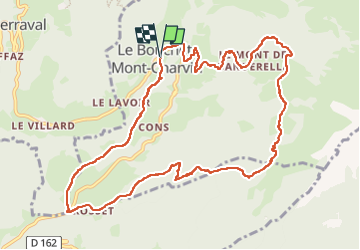

Length
12.3 km

Max alt
1497 m

Uphill gradient
755 m
Km-Effort
22 km

Min alt
830 m

Downhill gradient
744 m
Boucle
Yes
Creation date :
2025-05-08 06:51:38.723
Updated on :
2025-05-08 14:46:58.069
3h29
Difficulty : Very difficult

FREE GPS app for hiking
 SityTrail
IGN / Geographical institutes
SityTrail Plus
The world is yours!
About
Trail Walking of 12.3 km to be discovered at Auvergne-Rhône-Alpes, Upper Savoy, Le Bouchet-Mont-Charvin. This trail is proposed by Louna .
Positioning
Country:
France
Region :
Auvergne-Rhône-Alpes
Department/Province :
Upper Savoy
Municipality :
Le Bouchet-Mont-Charvin
Location:
Unknown
Start:(Dec)
Start:(UTM)
295201 ; 5074958 (32T) N.
Comments